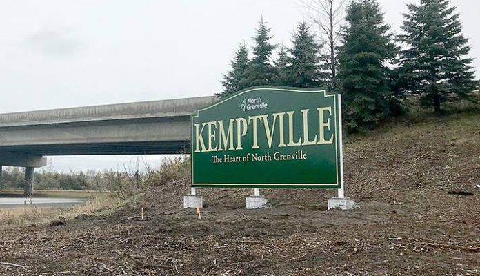
Drivers coming off the 416 on to County Road 43 or passing the Van Buren overpass may have noticed new Kemptville signs on the side of the highway. They read: “Kemptville”, with “The Heart of North Grenville” in smaller lettering underneath and the North Grenville logo above. They are of the standard design used for all municipal signage, originally developed by TD Graham + Associates in 2008.
These two highway signs have been the subject of some discussion on social media since they were erected a few weeks ago. Residents have expressed themselves for and against them, and the arguments seem to reflect a persistent divide with North Grenville that has dated from amalgamation. Those opposed to the wording on the signs claim that it simply reinforces the idea that Kemptville is North Grenville, and ignores the rural population, which, after all, forms the majority of North Grenville residents.
“Why can’t it just say North Grenville?”, is one of the main objections expressed. “Also ‘the heart of North Grenville’ like the hamlets hate us enough already”. “We are not Kemptville, we are North Grenville”. Others take a more moderate view: “Not to play the devil’s advocate here…but the sign does have North Grenville on it and I don’t think North Grenville is on any maps or GPSs while Kemptville is.”
Others just don’t like the design itself. “I just find it plain and unattractive. I know it matches others signs around NG, I just don’t find it inviting compared to other entrances I have seen around the country.” While some residents wonder how much the things cost: “I live and pay taxes in North Grenville not Kemptville, I do not pay to have my taxes wasted like this.”
On the one hand, it is very good to know that people care enough to think about these issues, and some of the comments suggested that the new council might look into updating the branding and design of the municipality’s signs.
The question of who decided on the wording was also something people wondered about, and whether there had been any public consultation before approving it. But the entire process has taken a very long time to come to fruition, and most people have forgotten how the process even started. Phil Gerrard, Director of Planning & Development for the Municipality, told the Times that “it has been a lengthy process getting all the required approvals from MTO, Hydro One, Ontario One‑Call, etc. This project was approved as part of the 2018 Capital Budget. Tom Graham did the design work and the whole project is based on the 2010 Signs Strategy, which echoed my staff report from 2006″.
Tom Graham, of TD Graham + Associates, told us that the “Tagline: ‘Heart of North Grenville’, was chosen as a phrase to include the name of the municipality (North Grenville), while emphasizing Kemptville as the major urban centre (shopping, banking, schools, gas, food, etc.).”
The landscaping has yet to be performed, as well as the installation of lighting , and this will certainly make a difference to the look of the signs. As for cost, Tom Graham notes that the signs were “originally part of a proposed $255,000, 4-year capital plan that included Destination signs, Service Club signs, Downtown banners and heritage street lamps, only the Destination Signs were approved, for $60,000.” This amount includes the signs themselves, installation and landscaping. The two highway signs were made by local sign maker Classic Graphics.


I agree with the “Kemptville” sign high light. Just go to Ottawa and ask people to come out to North Grenville, the majority will not know where it is. Say Kemptville, and they know where it is. People go to Merrickville. They have no idea that it is in NG.
Because Merrick is not in North grenville,
Townships are funny things, not adhering to actual roads. Perimeters of NG: on West: an imaginary straight line just west of Bolton Rd (which north of 43 is Davis Rd); on North: Rideau River (waterway, not the road of same name); on East : an imaginary straight line close to Boundary Rd (plus little bit at NE corner, up to River Rd 19 and Dalmeny Rd 4), and ignoring deviation at Cameron, down to Latimer; on South : an imaginary line that approximates Latimer Rd, then across to Totem Ranch Rd (north side is in NG, south side is Edmond Township), and continues across on Limerick Rd to Bishop’s Mills (where Bolton meets Harvey). Check out zoning map at northgrenville.on.ca. Google Maps does recognize “North Grenville” but puts the pin around McGovern and Rock Rd.